


Candé saint Martin Fontevraud

taguette
User
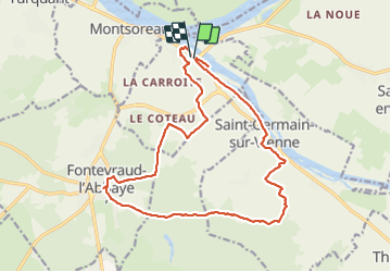

Length
18.5 km

Max alt
113 m

Uphill gradient
284 m
Km-Effort
22 km

Min alt
27 m

Downhill gradient
282 m
Boucle
Yes
Creation date :
2022-04-12 07:14:49.193
Updated on :
2022-04-12 11:12:25.553
3h54
Difficulty : Medium

FREE GPS app for hiking
 SityTrail
IGN / Geographical institutes
SityTrail Plus
The world is yours!
About
Trail Walking of 18.5 km to be discovered at Centre-Loire Valley, Indre-et-Loire, Candes-Saint-Martin. This trail is proposed by taguette.
Positioning
Country:
France
Region :
Centre-Loire Valley
Department/Province :
Indre-et-Loire
Municipality :
Candes-Saint-Martin
Location:
Unknown
Start:(Dec)
Start:(UTM)
278701 ; 5232589 (31T) N.
Comments