


Tavey bethoncourt

Danielj
User
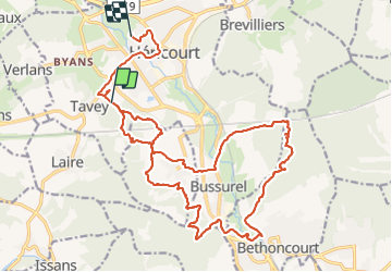

Length
25 km

Max alt
426 m

Uphill gradient
476 m
Km-Effort
31 km

Min alt
317 m

Downhill gradient
483 m
Boucle
No
Creation date :
2022-04-12 07:40:39.0
Updated on :
2022-04-12 15:06:26.301
5h38
Difficulty : Very difficult

FREE GPS app for hiking
 SityTrail
IGN / Geographical institutes
SityTrail Plus
The world is yours!
About
Trail Walking of 25 km to be discovered at Bourgogne-Franche-Comté, Haute-Saône, Héricourt. This trail is proposed by Danielj.
Positioning
Country:
France
Region :
Bourgogne-Franche-Comté
Department/Province :
Haute-Saône
Municipality :
Héricourt
Location:
Unknown
Start:(Dec)
Start:(UTM)
330458 ; 5270328 (32T) N.
Comments