


Les gaillardes

Christian13
User
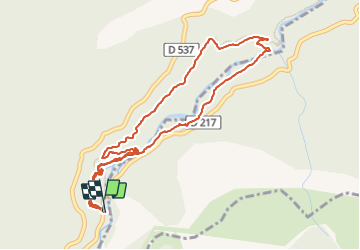

Length
5.3 km

Max alt
936 m

Uphill gradient
133 m
Km-Effort
7.1 km

Min alt
836 m

Downhill gradient
133 m
Boucle
Yes
Creation date :
2022-04-12 14:39:08.0
Updated on :
2022-04-12 16:43:06.458
2h03
Difficulty : Very easy

FREE GPS app for hiking
 SityTrail
IGN / Geographical institutes
SityTrail Plus
The world is yours!
About
Trail Walking of 5.3 km to be discovered at Auvergne-Rhône-Alpes, Isère, Pellafol. This trail is proposed by Christian13.
Description
Boucle
Positioning
Country:
France
Region :
Auvergne-Rhône-Alpes
Department/Province :
Isère
Municipality :
Pellafol
Location:
Unknown
Start:(Dec)
Start:(UTM)
728501 ; 4960043 (31T) N.
Comments