


COL DE LARY JP

mitch1952
User
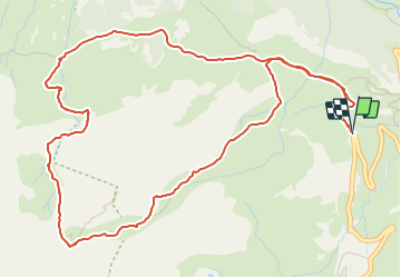

Length
7.3 km

Max alt
2273 m

Uphill gradient
570 m
Km-Effort
14.9 km

Min alt
1716 m

Downhill gradient
575 m
Boucle
Yes
Creation date :
2022-04-12 19:55:50.285
Updated on :
2022-04-12 20:05:12.442
3h23
Difficulty : Difficult

FREE GPS app for hiking
 SityTrail
IGN / Geographical institutes
SityTrail Plus
The world is yours!
About
Trail Walking of 7.3 km to be discovered at Occitania, Hautespyrenees, Gavarnie-Gèdre. This trail is proposed by mitch1952.
Positioning
Country:
France
Region :
Occitania
Department/Province :
Hautespyrenees
Municipality :
Gavarnie-Gèdre
Location:
Gavarnie
Start:(Dec)
Start:(UTM)
743061 ; 4735906 (30T) N.
Comments