


Signes sur les traces de Manon

bernir
User
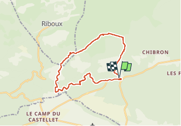

Length
15.4 km

Max alt
561 m

Uphill gradient
273 m
Km-Effort
19.1 km

Min alt
365 m

Downhill gradient
273 m
Boucle
Yes
Creation date :
2022-04-14 06:54:43.77
Updated on :
2022-04-14 17:13:42.779
6h19
Difficulty : Medium

FREE GPS app for hiking
 SityTrail
IGN / Geographical institutes
SityTrail Plus
The world is yours!
About
Trail Walking of 15.4 km to be discovered at Provence-Alpes-Côte d'Azur, Var, Signes. This trail is proposed by bernir.
Photos


Positioning
Country:
France
Region :
Provence-Alpes-Côte d'Azur
Department/Province :
Var
Municipality :
Signes
Location:
Unknown
Start:(Dec)
Start:(UTM)
727408 ; 4795289 (31T) N.
Comments