


Ve.deil Septvaux VF

MERMOZ33
User

Length
24 km

Max alt
209 m

Uphill gradient
333 m
Km-Effort
28 km

Min alt
45 m

Downhill gradient
243 m
Boucle
No
Creation date :
2022-04-14 06:41:26.085
Updated on :
2022-04-14 13:31:31.57
6h49
Difficulty : Medium

FREE GPS app for hiking
 SityTrail
IGN / Geographical institutes
SityTrail Plus
The world is yours!
About
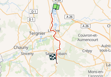
Trail Walking of 24 km to be discovered at Hauts-de-France, Aisne, Vendeuil. This trail is proposed by MERMOZ33.
Description
bon parcourt
Positioning
Country:
France
Region :
Hauts-de-France
Department/Province :
Aisne
Municipality :
Vendeuil
Location:
Unknown
Start:(Dec)
Start:(UTM)
525787 ; 5506788 (31U) N.
Comments