


W20_Mertert/Trèves

Léonidas
User
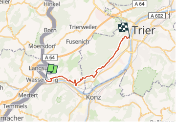

Length
14.7 km

Max alt
226 m

Uphill gradient
302 m
Km-Effort
18.7 km

Min alt
131 m

Downhill gradient
305 m
Boucle
No
Creation date :
2022-04-16 10:18:00.232
Updated on :
2022-04-16 11:16:11.934
1h07
Difficulty : Easy

FREE GPS app for hiking
 SityTrail
IGN / Geographical institutes
SityTrail Plus
The world is yours!
About
Trail Walking of 14.7 km to be discovered at Unknown, Canton Grevenmacher, Mertert. This trail is proposed by Léonidas.
Positioning
Country:
Luxembourg
Region :
Unknown
Department/Province :
Canton Grevenmacher
Municipality :
Mertert
Location:
Unknown
Start:(Dec)
Start:(UTM)
320224 ; 5509854 (32U) N.
Comments