


Chécy Mardié

taguette
User
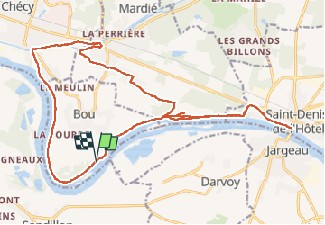

Length
24 km

Max alt
115 m

Uphill gradient
205 m
Km-Effort
27 km

Min alt
91 m

Downhill gradient
204 m
Boucle
Yes
Creation date :
2022-04-16 06:27:28.029
Updated on :
2022-04-16 11:06:48.543
4h36
Difficulty : Difficult

FREE GPS app for hiking
 SityTrail
IGN / Geographical institutes
SityTrail Plus
The world is yours!
About
Trail Walking of 24 km to be discovered at Centre-Loire Valley, Loiret, Bou. This trail is proposed by taguette.
Positioning
Country:
France
Region :
Centre-Loire Valley
Department/Province :
Loiret
Municipality :
Bou
Location:
Unknown
Start:(Dec)
Start:(UTM)
429024 ; 5301367 (31T) N.
Comments