


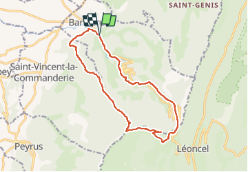
ASPTT Pas de St Vincent Pierre Chauve

TOULAUDIN
User

Length
16.1 km

Max alt
1297 m

Uphill gradient
899 m
Km-Effort
28 km

Min alt
427 m

Downhill gradient
897 m
Boucle
Yes
Creation date :
2022-04-17 06:39:12.198
Updated on :
2022-04-24 11:41:48.205
6h47
Difficulty : Difficult

FREE GPS app for hiking
 SityTrail
IGN / Geographical institutes
SityTrail Plus
The world is yours!
About
Trail Walking of 16.1 km to be discovered at Auvergne-Rhône-Alpes, Drôme, Barbières. This trail is proposed by TOULAUDIN.
Description
trace réelle rando réalisée le 17-4-22
Positioning
Country:
France
Region :
Auvergne-Rhône-Alpes
Department/Province :
Drôme
Municipality :
Barbières
Location:
Unknown
Start:(Dec)
Start:(UTM)
669259 ; 4979779 (31T) N.
Comments