


activity_8654165004

narberd
User
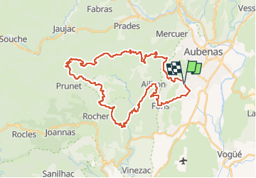

Length
42 km

Max alt
849 m

Uphill gradient
1115 m
Km-Effort
57 km

Min alt
200 m

Downhill gradient
1109 m
Boucle
Yes
Creation date :
2022-04-17 17:26:59.156
Updated on :
2022-04-17 17:28:43.708
3h58
Difficulty : Very difficult

FREE GPS app for hiking
 SityTrail
IGN / Geographical institutes
SityTrail Plus
The world is yours!
About
Trail Mountain bike of 42 km to be discovered at Auvergne-Rhône-Alpes, Ardèche, Saint-Étienne-de-Fontbellon. This trail is proposed by narberd.
Description
42 km dans l'arrière pays albenassien
Positioning
Country:
France
Region :
Auvergne-Rhône-Alpes
Department/Province :
Ardèche
Municipality :
Saint-Étienne-de-Fontbellon
Location:
Unknown
Start:(Dec)
Start:(UTM)
608900 ; 4939208 (31T) N.
Comments