


autour de veillins

lecmic
User
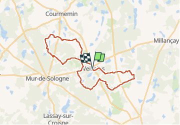

Length
32 km

Max alt
138 m

Uphill gradient
275 m
Km-Effort
36 km

Min alt
102 m

Downhill gradient
276 m
Boucle
Yes
Creation date :
2022-04-18 04:47:45.776
Updated on :
2022-04-18 09:51:03.754
4h57
Difficulty : Medium

FREE GPS app for hiking
 SityTrail
IGN / Geographical institutes
SityTrail Plus
The world is yours!
About
Trail Walking of 32 km to be discovered at Centre-Loire Valley, Loir-et-Cher, Veilleins. This trail is proposed by lecmic.
Description
rando
Positioning
Country:
France
Region :
Centre-Loire Valley
Department/Province :
Loir-et-Cher
Municipality :
Veilleins
Location:
Unknown
Start:(Dec)
Start:(UTM)
399687 ; 5252840 (31T) N.
Comments