


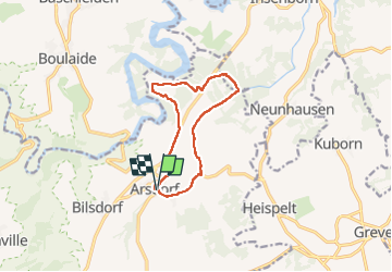
Autopedestre arsdorf
© OpenStreetMap contributors


2h13
Difficulty : Difficult


Length
9.8 km
Max alt
483 m
Uphill gradient
267 m
Km-Effort
13.3 km
Min alt
373 m
Downhill gradient
266 m
Boucle
Yes
Creation date :
2022-04-18 11:05:59.0
Updated on :
2022-04-18 13:23:06.659
2h13
Difficulty : Difficult
FREE GPS app for hiking
 SityTrail
IGN / Geographical institutes
SityTrail Plus
The world is yours!
About
Trail Walking of 9.8 km to be discovered at Unknown, Canton Redange, Rambrouch. This trail is proposed by 001566.93597aed761d48b4b868fa52b8ba7770.1817.
Positioning
Country:
Luxembourg
Region :
Unknown
Department/Province :
Canton Redange
Municipality :
Rambrouch
Location:
Unknown
Start:(Dec)
Start:(UTM)
704375 ; 5526958 (31U) N.
Comments