


Chemillieu 01

Henri.Vekemans
User
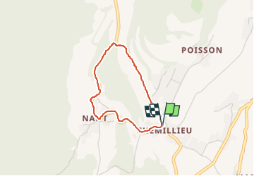

Length
2.7 km

Max alt
465 m

Uphill gradient
57 m
Km-Effort
3.5 km

Min alt
411 m

Downhill gradient
55 m
Boucle
Yes
Creation date :
2022-04-18 13:09:20.405
Updated on :
2022-04-18 13:56:55.89
47m
Difficulty : Easy

FREE GPS app for hiking
 SityTrail
IGN / Geographical institutes
SityTrail Plus
The world is yours!
About
Trail Walking of 2.7 km to be discovered at Auvergne-Rhône-Alpes, Ain, Parves-et-Nattages. This trail is proposed by Henri.Vekemans.
Description
randonnée
Positioning
Country:
France
Region :
Auvergne-Rhône-Alpes
Department/Province :
Ain
Municipality :
Parves-et-Nattages
Location:
Nattages
Start:(Dec)
Start:(UTM)
713697 ; 5066570 (31T) N.
Comments