


tour avallon

Tof Tof
User
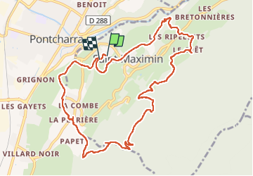

Length
11.8 km

Max alt
714 m

Uphill gradient
561 m
Km-Effort
19.3 km

Min alt
301 m

Downhill gradient
555 m
Boucle
Yes
Creation date :
2022-04-18 13:02:00.676
Updated on :
2022-04-18 16:12:19.868
3h10
Difficulty : Medium

FREE GPS app for hiking
 SityTrail
IGN / Geographical institutes
SityTrail Plus
The world is yours!
About
Trail Walking of 11.8 km to be discovered at Auvergne-Rhône-Alpes, Isère, Saint-Maximin. This trail is proposed by Tof Tof.
Positioning
Country:
France
Region :
Auvergne-Rhône-Alpes
Department/Province :
Isère
Municipality :
Saint-Maximin
Location:
Unknown
Start:(Dec)
Start:(UTM)
267895 ; 5034971 (32T) N.
Comments