


St Pierre de Boeuf Maclas

psesjs
User
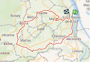

Length
21 km

Max alt
475 m

Uphill gradient
484 m
Km-Effort
27 km

Min alt
138 m

Downhill gradient
469 m
Boucle
Yes
Creation date :
2022-04-20 07:24:14.835
Updated on :
2022-04-20 13:48:44.653
5h03
Difficulty : Easy

FREE GPS app for hiking
 SityTrail
IGN / Geographical institutes
SityTrail Plus
The world is yours!
About
Trail Walking of 21 km to be discovered at Auvergne-Rhône-Alpes, Loire, Saint-Pierre-de-Bœuf. This trail is proposed by psesjs.
Positioning
Country:
France
Region :
Auvergne-Rhône-Alpes
Department/Province :
Loire
Municipality :
Saint-Pierre-de-Bœuf
Location:
Unknown
Start:(Dec)
Start:(UTM)
637001 ; 5027153 (31T) N.
Comments