


Hantés Wiheries 20 04 22

andremusin
User
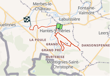

Length
11.5 km

Max alt
172 m

Uphill gradient
108 m
Km-Effort
13 km

Min alt
119 m

Downhill gradient
114 m
Boucle
No
Creation date :
2022-04-20 12:21:07.238
Updated on :
2022-04-20 15:22:22.809
2h35
Difficulty : Very easy

FREE GPS app for hiking
 SityTrail
IGN / Geographical institutes
SityTrail Plus
The world is yours!
About
Trail Walking of 11.5 km to be discovered at Wallonia, Hainaut, Erquelinnes. This trail is proposed by andremusin.
Positioning
Country:
Belgium
Region :
Wallonia
Department/Province :
Hainaut
Municipality :
Erquelinnes
Location:
Unknown
Start:(Dec)
Start:(UTM)
583924 ; 5573079 (31U) N.
Comments