


étape liaison SJC

erisel
User
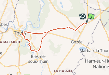

Length
14.3 km

Max alt
212 m

Uphill gradient
145 m
Km-Effort
16.3 km

Min alt
134 m

Downhill gradient
145 m
Boucle
Yes
Creation date :
2022-04-20 18:46:30.006
Updated on :
2022-04-21 16:08:04.057
2h50
Difficulty : Easy

FREE GPS app for hiking
 SityTrail
IGN / Geographical institutes
SityTrail Plus
The world is yours!
About
Trail On foot of 14.3 km to be discovered at Wallonia, Hainaut, Thuin. This trail is proposed by erisel.
Description
étape de liaison dans notre chemin de Saint Jacques
Photos


Positioning
Country:
Belgium
Region :
Wallonia
Department/Province :
Hainaut
Municipality :
Thuin
Location:
Unknown
Start:(Dec)
Start:(UTM)
597006 ; 5578054 (31U) N.
Comments