


les crêtes

Diogene99
User
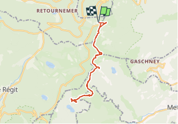

Length
15.2 km

Max alt
1355 m

Uphill gradient
566 m
Km-Effort
23 km

Min alt
1092 m

Downhill gradient
566 m
Boucle
Yes
Creation date :
2022-04-20 09:07:36.965
Updated on :
2022-04-20 22:33:59.679
6h06
Difficulty : Medium

FREE GPS app for hiking
 SityTrail
IGN / Geographical institutes
SityTrail Plus
The world is yours!
About
Trail Walking of 15.2 km to be discovered at Grand Est, Vosges, Xonrupt-Longemer. This trail is proposed by Diogene99.
Description
top
Positioning
Country:
France
Region :
Grand Est
Department/Province :
Vosges
Municipality :
Xonrupt-Longemer
Location:
Unknown
Start:(Dec)
Start:(UTM)
352045 ; 5324017 (32U) N.
Comments