Trail Walking Saint-Diéry - 
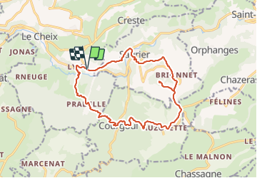
St_Diery_Mont_Carmel - Photo
 jagarnier
jagarnier

User GUIDE

© OpenStreetMap contributors
Length
Length
16.8 km
Max alt
Max alt
905 m
Uphill gradient
Uphill gradient
771 m
Km-Effort
Km-Effort  
27 km
Min alt
Min alt
550 m
Downhill gradient
Downhill gradient
770 m
Boucle
Boucle
Yes
Creation date :
2022-04-21 05:29:53.749
Updated on :
2023-06-22 07:50:25.378

(0 Reviews)

Walking
Walking
5h00
Difficulty : Difficult

Scan this QR Code to open this trail in the SityTrail application

FREE GPS app for hiking

Logo SityTrail SityTrail

IGN / Geographical institutes

Download SityTrail from the App Store Download SityTrail from Google Play

Logo SityTrail SityTrail Plus

The world is yours!

Download SityTrail from the App Store Download SityTrail from Google Play Download SityTrail on Huawei AppGallery

About

Trail Walking of 16.8 km to be discovered at Auvergne-Rhône-Alpes, Puy-de-Dôme, Saint-Diéry. This trail is proposed by jagarnier.

Description

Un site magique. La chapelle est perchée sur son piton basaltique à 927 mètres d'altitude. De là-haut, la vue est absolument magnifique : Vous embrasserez l'Auvergne avec la chaîne des Puys, le massif du Sancy et la vallée de la Couze Pavin.

Elevation profile

Photos

Positioning

Country:
France
Region :
Auvergne-Rhône-Alpes
Department/Province :
Puy-de-Dôme
Municipality :
Saint-Diéry
Location:
Saint-Diéry
Start:(UTM)
501858 ; 5042121 (31T) N.


Close
My subscriptions