


Mézières - Domaine de Bellebouche

zanogueb
User
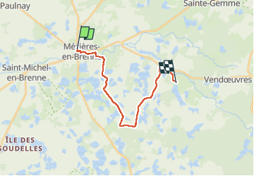

Length
17.7 km

Max alt
112 m

Uphill gradient
94 m
Km-Effort
18.9 km

Min alt
86 m

Downhill gradient
75 m
Boucle
No
Creation date :
2022-04-21 07:17:44.642
Updated on :
2022-04-23 07:23:47.341
3h59
Difficulty : Medium

FREE GPS app for hiking
 SityTrail
IGN / Geographical institutes
SityTrail Plus
The world is yours!
About
Trail Walking of 17.7 km to be discovered at Centre-Loire Valley, Indre, Mézières-en-Brenne. This trail is proposed by zanogueb.
Description
Départ du centre ville de Mézières-en-Brenne. Randonnée entre les nombreux étangs de la Brenne jusqu'au Domaine de Bellebouche.
Photos


Positioning
Country:
France
Region :
Centre-Loire Valley
Department/Province :
Indre
Municipality :
Mézières-en-Brenne
Location:
Unknown
Start:(Dec)
Start:(UTM)
363388 ; 5186859 (31T) N.
Comments