


etrigny

mcterret
User
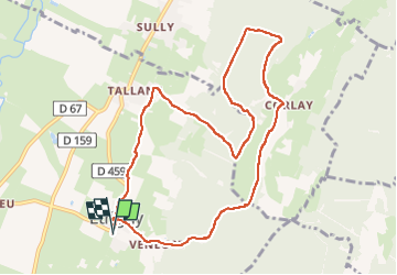

Length
10.2 km

Max alt
394 m

Uphill gradient
313 m
Km-Effort
14.4 km

Min alt
238 m

Downhill gradient
313 m
Boucle
Yes
Creation date :
2022-04-21 12:33:21.475
Updated on :
2022-04-21 15:22:42.171
2h34
Difficulty : Medium

FREE GPS app for hiking
 SityTrail
IGN / Geographical institutes
SityTrail Plus
The world is yours!
About
Trail Walking of 10.2 km to be discovered at Bourgogne-Franche-Comté, Saône-et-Loire, Étrigny. This trail is proposed by mcterret.
Positioning
Country:
France
Region :
Bourgogne-Franche-Comté
Department/Province :
Saône-et-Loire
Municipality :
Étrigny
Location:
Unknown
Start:(Dec)
Start:(UTM)
638138 ; 5161054 (31T) N.
Comments