


vineuil

gerardh
User
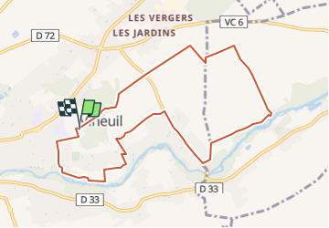

Length
9.6 km

Max alt
98 m

Uphill gradient
90 m
Km-Effort
10.8 km

Min alt
70 m

Downhill gradient
90 m
Boucle
Yes
Creation date :
2022-04-21 16:25:59.518
Updated on :
2022-04-21 16:27:13.173
2h27
Difficulty : Medium

FREE GPS app for hiking
 SityTrail
IGN / Geographical institutes
SityTrail Plus
The world is yours!
About
Trail Walking of 9.6 km to be discovered at Centre-Loire Valley, Loir-et-Cher, Vineuil. This trail is proposed by gerardh.
Description
par les grotteaux
villoiseau
nanteuil
bord cosson
Positioning
Country:
France
Region :
Centre-Loire Valley
Department/Province :
Loir-et-Cher
Municipality :
Vineuil
Location:
Unknown
Start:(Dec)
Start:(UTM)
378579 ; 5271408 (31T) N.
Comments