


Villers la ville (à faire vélo)

jacthiry
User
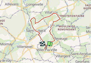

Length
13.7 km

Max alt
306 m

Uphill gradient
200 m
Km-Effort
16.3 km

Min alt
262 m

Downhill gradient
202 m
Boucle
Yes
Creation date :
2022-04-21 12:02:39.355
Updated on :
2022-04-21 16:39:11.012
3h46
Difficulty : Difficult

FREE GPS app for hiking
 SityTrail
IGN / Geographical institutes
SityTrail Plus
The world is yours!
About
Trail Walking of 13.7 km to be discovered at Bourgogne-Franche-Comté, Haute-Saône, Villers-la-Ville. This trail is proposed by jacthiry.
Positioning
Country:
France
Region :
Bourgogne-Franche-Comté
Department/Province :
Haute-Saône
Municipality :
Villers-la-Ville
Location:
Unknown
Start:(Dec)
Start:(UTM)
309106 ; 5269172 (32T) N.
Comments