


G4 Saint Sever de Rustan fait2022

LouisROGER
User GUIDE
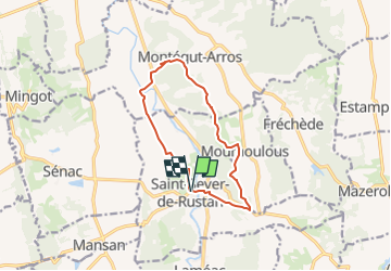

Length
11.7 km

Max alt
294 m

Uphill gradient
206 m
Km-Effort
14.5 km

Min alt
177 m

Downhill gradient
206 m
Boucle
Yes
Creation date :
2022-04-22 07:14:54.007
Updated on :
2022-04-23 11:35:54.889
3h26
Difficulty : Difficult

FREE GPS app for hiking
 SityTrail
IGN / Geographical institutes
SityTrail Plus
The world is yours!
About
Trail Walking of 11.7 km to be discovered at Occitania, Hautespyrenees, Saint-Sever-de-Rustan. This trail is proposed by LouisROGER.
Positioning
Country:
France
Region :
Occitania
Department/Province :
Hautespyrenees
Municipality :
Saint-Sever-de-Rustan
Location:
Unknown
Start:(Dec)
Start:(UTM)
275035 ; 4803580 (31T) N.
Comments