


Trace St Savin Sarrat Broucous G2

mitch1952
User
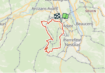

Length
13.5 km

Max alt
1339 m

Uphill gradient
854 m
Km-Effort
25 km

Min alt
547 m

Downhill gradient
857 m
Boucle
Yes
Creation date :
2022-04-22 06:55:53.0
Updated on :
2022-04-22 13:34:24.685
4h26
Difficulty : Unknown

FREE GPS app for hiking
 SityTrail
IGN / Geographical institutes
SityTrail Plus
The world is yours!
About
Trail Walking of 13.5 km to be discovered at Occitania, Hautespyrenees, Saint-Savin. This trail is proposed by mitch1952.
Positioning
Country:
France
Region :
Occitania
Department/Province :
Hautespyrenees
Municipality :
Saint-Savin
Location:
Unknown
Start:(Dec)
Start:(UTM)
737515 ; 4762295 (30T) N.
Comments