


RIF-04-22-7 du 22.04.2022

bene_dictus77
User
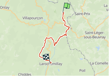

Length
21 km

Max alt
815 m

Uphill gradient
723 m
Km-Effort
31 km

Min alt
322 m

Downhill gradient
991 m
Boucle
No
Creation date :
2022-04-22 07:06:55.062
Updated on :
2022-04-22 15:10:31.419
7h17
Difficulty : Easy

FREE GPS app for hiking
 SityTrail
IGN / Geographical institutes
SityTrail Plus
The world is yours!
About
Trail Walking of 21 km to be discovered at Bourgogne-Franche-Comté, Nièvre, Glux-en-Glenne. This trail is proposed by bene_dictus77.
Description
de Glux en Glenne à la Roche Millet
Positioning
Country:
France
Region :
Bourgogne-Franche-Comté
Department/Province :
Nièvre
Municipality :
Glux-en-Glenne
Location:
Unknown
Start:(Dec)
Start:(UTM)
578269 ; 5200929 (31T) N.
Comments