


GS Manternach Jour 1

Mercenier
User
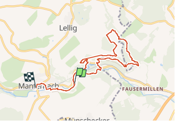

Length
8.9 km

Max alt
287 m

Uphill gradient
238 m
Km-Effort
12.1 km

Min alt
182 m

Downhill gradient
253 m
Boucle
No
Creation date :
2022-04-22 09:27:58.213
Updated on :
2022-04-22 18:30:27.693
3h10
Difficulty : Difficult

FREE GPS app for hiking
 SityTrail
IGN / Geographical institutes
SityTrail Plus
The world is yours!
About
Trail Walking of 8.9 km to be discovered at Unknown, Canton Grevenmacher, Manternach. This trail is proposed by Mercenier.
Positioning
Country:
Luxembourg
Region :
Unknown
Department/Province :
Canton Grevenmacher
Municipality :
Manternach
Location:
Unknown
Start:(Dec)
Start:(UTM)
315222 ; 5509285 (32U) N.
Comments