


Lasalle-Mont Brion-Soudorgues

ARVIEU
User
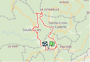

Length
16.5 km

Max alt
811 m

Uphill gradient
714 m
Km-Effort
26 km

Min alt
274 m

Downhill gradient
715 m
Boucle
Yes
Creation date :
2022-04-23 06:22:18.863
Updated on :
2022-04-23 06:23:18.575
6h00
Difficulty : Difficult

FREE GPS app for hiking
 SityTrail
IGN / Geographical institutes
SityTrail Plus
The world is yours!
About
Trail Walking of 16.5 km to be discovered at Occitania, Gard, Lasalle. This trail is proposed by ARVIEU.
Photos

Positioning
Country:
France
Region :
Occitania
Department/Province :
Gard
Municipality :
Lasalle
Location:
Unknown
Start:(Dec)
Start:(UTM)
568311 ; 4877231 (31T) N.
Comments