


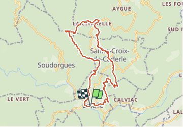
Lasalle - Ste Croix de Caderle - Mont Brion

ARVIEU
User

Length
18.5 km

Max alt
811 m

Uphill gradient
822 m
Km-Effort
29 km

Min alt
274 m

Downhill gradient
823 m
Boucle
Yes
Creation date :
2022-04-23 09:09:59.667
Updated on :
2022-04-23 09:12:16.396
6h30
Difficulty : Difficult

FREE GPS app for hiking
 SityTrail
IGN / Geographical institutes
SityTrail Plus
The world is yours!
About
Trail Walking of 18.5 km to be discovered at Occitania, Gard, Lasalle. This trail is proposed by ARVIEU.
Photos

Positioning
Country:
France
Region :
Occitania
Department/Province :
Gard
Municipality :
Lasalle
Location:
Unknown
Start:(Dec)
Start:(UTM)
568297 ; 4877241 (31T) N.
Comments