


GS Mullertal

Mercenier
User
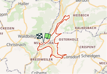

Length
16.8 km

Max alt
361 m

Uphill gradient
370 m
Km-Effort
22 km

Min alt
211 m

Downhill gradient
368 m
Boucle
Yes
Creation date :
2022-04-23 07:44:37.674
Updated on :
2022-04-23 20:17:23.192
5h57
Difficulty : Very difficult

FREE GPS app for hiking
 SityTrail
IGN / Geographical institutes
SityTrail Plus
The world is yours!
About
Trail Walking of 16.8 km to be discovered at Unknown, Canton Echternach, Waldbillig. This trail is proposed by Mercenier.
Positioning
Country:
Luxembourg
Region :
Unknown
Department/Province :
Canton Echternach
Municipality :
Waldbillig
Location:
Unknown
Start:(Dec)
Start:(UTM)
306087 ; 5518803 (32U) N.
Comments