


pied de cote - signal saint pierre

JMJ42
User
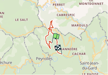

Length
10.2 km

Max alt
677 m

Uphill gradient
451 m
Km-Effort
16.5 km

Min alt
201 m

Downhill gradient
543 m
Boucle
No
Creation date :
2022-04-26 08:02:10.172
Updated on :
2022-04-26 12:57:39.136
2h59
Difficulty : Difficult

FREE GPS app for hiking
 SityTrail
IGN / Geographical institutes
SityTrail Plus
The world is yours!
About
Trail Walking of 10.2 km to be discovered at Occitania, Gard, Saint-Jean-du-Gard. This trail is proposed by JMJ42.
Positioning
Country:
France
Region :
Occitania
Department/Province :
Gard
Municipality :
Saint-Jean-du-Gard
Location:
Unknown
Start:(Dec)
Start:(UTM)
567354 ; 4885956 (31T) N.
Comments