


Hm

hm
User
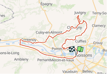

Length
41 km

Max alt
153 m

Uphill gradient
369 m
Km-Effort
46 km

Min alt
36 m

Downhill gradient
369 m
Boucle
Yes
Creation date :
2014-12-10 00:00:00.0
Updated on :
2014-12-10 00:00:00.0
2h45
Difficulty : Easy

FREE GPS app for hiking
 SityTrail
IGN / Geographical institutes
SityTrail Plus
The world is yours!
About
Trail Mountain bike of 41 km to be discovered at Hauts-de-France, Aisne, Soissons. This trail is proposed by hm.
Description
07/08/15
Positioning
Country:
France
Region :
Hauts-de-France
Department/Province :
Aisne
Municipality :
Soissons
Location:
Unknown
Start:(Dec)
Start:(UTM)
522482 ; 5470056 (31U) N.
Comments