


somme cocu

lionelnottat
User
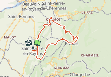

Length
16.8 km

Max alt
1002 m

Uphill gradient
827 m
Km-Effort
28 km

Min alt
371 m

Downhill gradient
827 m
Boucle
Yes
Creation date :
2022-04-26 06:33:16.348
Updated on :
2022-04-26 14:32:16.786
4h40
Difficulty : Difficult

FREE GPS app for hiking
 SityTrail
IGN / Geographical institutes
SityTrail Plus
The world is yours!
About
Trail Walking of 16.8 km to be discovered at Auvergne-Rhône-Alpes, Isère, Saint-André-en-Royans. This trail is proposed by lionelnottat.
Positioning
Country:
France
Region :
Auvergne-Rhône-Alpes
Department/Province :
Isère
Municipality :
Saint-André-en-Royans
Location:
Unknown
Start:(Dec)
Start:(UTM)
684123 ; 4995207 (31T) N.
Comments