


aller panoramas 04 2022

olivieraron
User
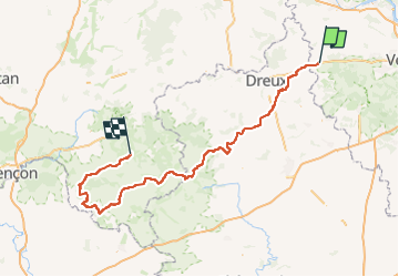

Length
179 km

Max alt
275 m

Uphill gradient
1830 m
Km-Effort
203 km

Min alt
82 m

Downhill gradient
1768 m
Boucle
No
Creation date :
2022-04-26 16:24:33.663
Updated on :
2022-04-26 16:24:33.663

FREE GPS app for hiking
 SityTrail
IGN / Geographical institutes
SityTrail Plus
The world is yours!
About
Trail of 179 km to be discovered at Ile-de-France, Yvelines, Maulette. This trail is proposed by olivieraron.
Positioning
Country:
France
Region :
Ile-de-France
Department/Province :
Yvelines
Municipality :
Maulette
Location:
Unknown
Start:(Dec)
Start:(UTM)
399533 ; 5405291 (31U) N.
Comments