Trail  Châtenay - 2022-04-27_07h12m06_boucle-chatenay-1-2 - Photo

2022-04-27_07h12m06_boucle-chatenay-1-2

© OpenStreetMap contributors
Length
Length
25 km
Max alt
Max alt
330 m
Uphill gradient
Uphill gradient
217 m
Km-Effort
Km-Effort  
28 km
Min alt
Min alt
277 m
Downhill gradient
Downhill gradient
214 m
Boucle
Boucle
Yes
Creation date :
2022-04-27 05:12:06.429
Updated on :
2022-04-27 05:12:06.561

(0 Reviews)


Scan this QR Code to open this trail in the SityTrail application

FREE GPS app for hiking

Logo SityTrail SityTrail

IGN / Geographical institutes

Download SityTrail from the App Store Download SityTrail from Google Play

Logo SityTrail SityTrail World

The world is yours!

Download SityTrail from the App Store Download SityTrail from Google Play Download SityTrail on Huawei AppGallery

About

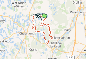
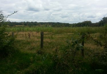
Trail of 25 km to be discovered at Auvergne-Rhône-Alpes, Ain, Châtenay. This trail is proposed by Pascale Pâris.

Description

Boucle à la journée au départ du relais "La Commanderie" à Châtenay de 25 km.
Beau circuit dans de jolis forêts et près d'étangs !
Pour cavalier et attelage.
mis à jour 30/03/2021

Elevation profile

Positioning

Country:
France
Region :
Auvergne-Rhône-Alpes
Department/Province :
Ain
Municipality :
Châtenay
Location:
Unknown
Start:(Dec)
Start:(UTM)
671346 ; 5098775 (31T) N.

Trails nearby

Trail Walking Châtillon-la-Palud - Petite course à pied tranquille - Châtillon la Palud - Photo
Walking
tracegps

Walking

Easy
(1)
Châtillon-la-Palud, Auvergne-Rhône-Alpes, Ain, France
6.3 km | 8.3 km-effort
1h 30min
Yes
Trail Running Châtillon-la-Palud - Petite course à pied tranquille - Châtillon la Palud - Photo
Running
tracegps

Running

Medium
Châtillon-la-Palud, Auvergne-Rhône-Alpes, Ain, France
6.3 km | 8.3 km-effort
34min
Yes
Trail Mountain bike Châtillon-la-Palud - Petite course à pied tranquille - Châtillon la Palud - Photo
Mountain bike
tracegps

Mountain bike

Easy
Châtillon-la-Palud, Auvergne-Rhône-Alpes, Ain, France
6.3 km | 8.3 km-effort
19min
Yes
Trail Walking Chalamont - Circuit de Chalamont - 10 km - Photo
Walking
tracegps

Walking

Medium
(1)
Chalamont, Auvergne-Rhône-Alpes, Ain, France
9.9 km | 11.4 km-effort
2h 30min
Yes
Trail Mountain bike Dompierre-sur-Veyle - Balade Solex autour de Dompierre sur Veyle - Photo
Mountain bike
BGO

Mountain bike

Very easy
Dompierre-sur-Veyle, Auvergne-Rhône-Alpes, Ain, France
30 km | 33 km-effort
2h 13min
Yes
Trail Walking Chalamont - chalamont cs - Photo
Walking
jpz

Walking

Easy
Chalamont, Auvergne-Rhône-Alpes, Ain, France
10.8 km | 12.4 km-effort
4h 5min
Yes
Trail Walking Druillat - le roset 1 - Photo
Walking
robert gallet

Walking

Difficult
Druillat, Auvergne-Rhône-Alpes, Ain, France
13.4 km | 15.9 km-effort
3h 36min
Yes
Trail sport Châtenay - 2022-03-14_17h26m53_boucle-chatenay-2 - Photo
sport
Pascale Pâris

sport

Very easy
Châtenay, Auvergne-Rhône-Alpes, Ain, France
25 km | 29 km-effort
Unknown
Yes
Trail sport Châtenay - 2022-03-14_16h16m34_boucle-chatenay-4 - Photo
sport
Pascale Pâris

sport

Very easy
Châtenay, Auvergne-Rhône-Alpes, Ain, France
32 km | 39 km-effort
Unknown
Yes


Close
My subscriptions