


montalet

suzanne.bron
User
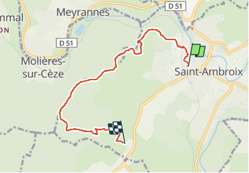

Length
6.8 km

Max alt
436 m

Uphill gradient
307 m
Km-Effort
10.6 km

Min alt
143 m

Downhill gradient
195 m
Boucle
No
Creation date :
2022-04-27 06:15:15.752
Updated on :
2022-04-27 09:05:02.627
2h31
Difficulty : Very easy

FREE GPS app for hiking
 SityTrail
IGN / Geographical institutes
SityTrail Plus
The world is yours!
About
Trail Nordic walking of 6.8 km to be discovered at Occitania, Gard, Saint-Ambroix. This trail is proposed by suzanne.bron.
Photos


Positioning
Country:
France
Region :
Occitania
Department/Province :
Gard
Municipality :
Saint-Ambroix
Location:
Unknown
Start:(Dec)
Start:(UTM)
595370 ; 4901557 (31T) N.
Comments