


L’Étang des Bésines

lebarça
User
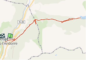

Length
14.2 km

Max alt
1989 m

Uphill gradient
692 m
Km-Effort
24 km

Min alt
1434 m

Downhill gradient
715 m
Boucle
Yes
Creation date :
2022-04-27 08:12:32.0
Updated on :
2022-04-27 14:54:20.766
6h40
Difficulty : Medium

FREE GPS app for hiking
 SityTrail
IGN / Geographical institutes
SityTrail Plus
The world is yours!
About
Trail Walking of 14.2 km to be discovered at Occitania, Ariège, L'Hospitalet-près-l'Andorre. This trail is proposed by lebarça.
Positioning
Country:
France
Region :
Occitania
Department/Province :
Ariège
Municipality :
L'Hospitalet-près-l'Andorre
Location:
Unknown
Start:(Dec)
Start:(UTM)
401465 ; 4715744 (31T) N.
Comments