


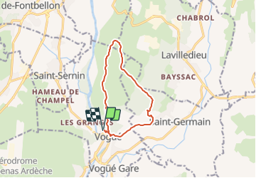
Vogüé, Serre-Bastel, Les Chazes

Rudy07
User

Length
10.6 km

Max alt
329 m

Uphill gradient
234 m
Km-Effort
13.7 km

Min alt
167 m

Downhill gradient
234 m
Boucle
Yes
Creation date :
2022-04-27 08:54:36.02
Updated on :
2023-12-28 14:49:35.944
3h06
Difficulty : Difficult

FREE GPS app for hiking
 SityTrail
IGN / Geographical institutes
SityTrail Plus
The world is yours!
About
Trail Walking of 10.6 km to be discovered at Auvergne-Rhône-Alpes, Ardèche, Vogüé. This trail is proposed by Rudy07.
Positioning
Country:
France
Region :
Auvergne-Rhône-Alpes
Department/Province :
Ardèche
Municipality :
Vogüé
Location:
Unknown
Start:(Dec)
Start:(UTM)
612253 ; 4934150 (31T) N.
Comments