


hThdrwED9yM

j.pont
User
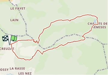

Length
10.9 km

Max alt
1696 m

Uphill gradient
702 m
Km-Effort
20 km

Min alt
1160 m

Downhill gradient
702 m
Boucle
Yes
Creation date :
2022-04-27 22:03:25.0
Updated on :
2022-04-27 22:03:27.021

FREE GPS app for hiking
 SityTrail
IGN / Geographical institutes
SityTrail Plus
The world is yours!
About
Trail of 10.9 km to be discovered at Auvergne-Rhône-Alpes, Upper Savoy, Bernex. This trail is proposed by j.pont.
Positioning
Country:
France
Region :
Auvergne-Rhône-Alpes
Department/Province :
Upper Savoy
Municipality :
Bernex
Location:
Unknown
Start:(Dec)
Start:(UTM)
322241 ; 5137745 (32T) N.
Comments