


Marac Langres VF

MERMOZ33
User
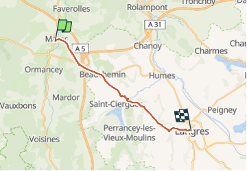

Length
15.1 km

Max alt
470 m

Uphill gradient
337 m
Km-Effort
19.2 km

Min alt
335 m

Downhill gradient
231 m
Boucle
No
Creation date :
2022-04-27 17:39:59.223
Updated on :
2022-04-28 10:50:22.877
17h09
Difficulty : Very easy

FREE GPS app for hiking
 SityTrail
IGN / Geographical institutes
SityTrail Plus
The world is yours!
About
Trail Walking of 15.1 km to be discovered at Grand Est, Haute-Marne, Marac. This trail is proposed by MERMOZ33.
Positioning
Country:
France
Region :
Grand Est
Department/Province :
Haute-Marne
Municipality :
Marac
Location:
Unknown
Start:(Dec)
Start:(UTM)
663930 ; 5310440 (31T) N.
Comments