


Marcigny Inguerande

taguette
User
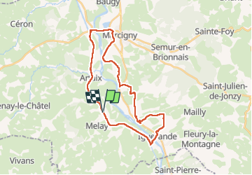

Length
29 km

Max alt
363 m

Uphill gradient
280 m
Km-Effort
33 km

Min alt
241 m

Downhill gradient
283 m
Boucle
Yes
Creation date :
2022-04-28 06:36:52.847
Updated on :
2022-04-28 13:30:37.04
6h09
Difficulty : Very difficult

FREE GPS app for hiking
 SityTrail
IGN / Geographical institutes
SityTrail Plus
The world is yours!
About
Trail Walking of 29 km to be discovered at Bourgogne-Franche-Comté, Saône-et-Loire, Melay. This trail is proposed by taguette.
Positioning
Country:
France
Region :
Bourgogne-Franche-Comté
Department/Province :
Saône-et-Loire
Municipality :
Melay
Location:
Unknown
Start:(Dec)
Start:(UTM)
578933 ; 5119195 (31T) N.
Comments