


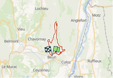
Grand Colombier

CLP01
User

Length
21 km

Max alt
1523 m

Uphill gradient
1408 m
Km-Effort
40 km

Min alt
293 m

Downhill gradient
1406 m
Boucle
Yes
Creation date :
2022-04-30 14:33:33.998
Updated on :
2022-04-30 14:34:08.214
9h07
Difficulty : Very difficult

FREE GPS app for hiking
 SityTrail
IGN / Geographical institutes
SityTrail Plus
The world is yours!
About
Trail Walking of 21 km to be discovered at Auvergne-Rhône-Alpes, Ain, Béon. This trail is proposed by CLP01.
Positioning
Country:
France
Region :
Auvergne-Rhône-Alpes
Department/Province :
Ain
Municipality :
Béon
Location:
Unknown
Start:(Dec)
Start:(UTM)
713578 ; 5081808 (31T) N.
Comments