


Mandeure via Glay

tiene
User
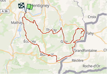

Length
47 km

Max alt
687 m

Uphill gradient
1119 m
Km-Effort
62 km

Min alt
332 m

Downhill gradient
1123 m
Boucle
No
Creation date :
2022-04-30 11:25:35.456
Updated on :
2022-04-30 19:18:48.765
3h18
Difficulty : Very difficult

FREE GPS app for hiking
 SityTrail
IGN / Geographical institutes
SityTrail Plus
The world is yours!
About
Trail Mountain bike of 47 km to be discovered at Bourgogne-Franche-Comté, Doubs, Mandeure. This trail is proposed by tiene.
Description
vtt
Positioning
Country:
France
Region :
Bourgogne-Franche-Comté
Department/Province :
Doubs
Municipality :
Mandeure
Location:
Unknown
Start:(Dec)
Start:(UTM)
334320 ; 5257512 (32T) N.
Comments