


2022-04-30

Lucquiaud
User
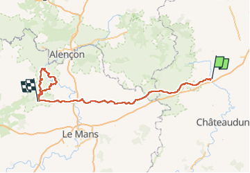

Length
216 km

Max alt
268 m

Uphill gradient
2869 m
Km-Effort
255 km

Min alt
53 m

Downhill gradient
2859 m
Boucle
No
Creation date :
2022-04-28 15:53:23.748
Updated on :
2022-04-30 19:05:22.717
48h33
Difficulty : Very difficult

FREE GPS app for hiking
 SityTrail
IGN / Geographical institutes
SityTrail Plus
The world is yours!
About
Trail Mountain bike of 216 km to be discovered at Centre-Loire Valley, Eure-et-Loir, Illiers-Combray. This trail is proposed by Lucquiaud.
Positioning
Country:
France
Region :
Centre-Loire Valley
Department/Province :
Eure-et-Loir
Municipality :
Illiers-Combray
Location:
Unknown
Start:(Dec)
Start:(UTM)
369828 ; 5351555 (31U) N.
Comments