


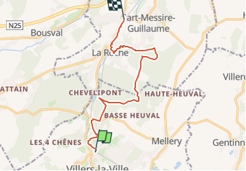
Stationswandeling Faux - Villers la Ville

FreddyTuerlinckx
User

Length
10.2 km

Max alt
154 m

Uphill gradient
204 m
Km-Effort
13 km

Min alt
73 m

Downhill gradient
227 m
Boucle
No
Creation date :
2022-05-01 07:51:45.21
Updated on :
2025-01-04 08:56:32.365
2h57
Difficulty : Easy

FREE GPS app for hiking
 SityTrail
IGN / Geographical institutes
SityTrail Plus
The world is yours!
About
Trail On foot of 10.2 km to be discovered at Wallonia, Walloon Brabant, Villers-la-Ville. This trail is proposed by FreddyTuerlinckx.
Positioning
Country:
Belgium
Region :
Wallonia
Department/Province :
Walloon Brabant
Municipality :
Villers-la-Ville
Location:
Villers-la-Ville
Start:(Dec)
Start:(UTM)
608556 ; 5604047 (31U) N.
Comments