


Dencé

taguette
User
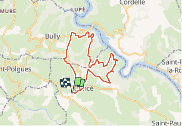

Length
16.2 km

Max alt
577 m

Uphill gradient
467 m
Km-Effort
22 km

Min alt
355 m

Downhill gradient
467 m
Boucle
Yes
Creation date :
2022-05-01 06:57:04.747
Updated on :
2022-05-01 10:45:21.64
3h45
Difficulty : Very difficult

FREE GPS app for hiking
 SityTrail
IGN / Geographical institutes
SityTrail Plus
The world is yours!
About
Trail Walking of 16.2 km to be discovered at Auvergne-Rhône-Alpes, Loire, Vézelin-sur-Loire. This trail is proposed by taguette.
Positioning
Country:
France
Region :
Auvergne-Rhône-Alpes
Department/Province :
Loire
Municipality :
Vézelin-sur-Loire
Location:
Dancé
Start:(Dec)
Start:(UTM)
579130 ; 5083493 (31T) N.
Comments