


Charnay chanoinesses

ppn
User
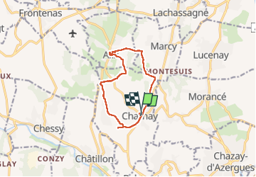

Length
10.6 km

Max alt
445 m

Uphill gradient
296 m
Km-Effort
14.5 km

Min alt
250 m

Downhill gradient
279 m
Boucle
Yes
Creation date :
2022-05-01 08:05:14.132
Updated on :
2022-05-01 12:12:08.915
3h55
Difficulty : Medium

FREE GPS app for hiking
 SityTrail
IGN / Geographical institutes
SityTrail Plus
The world is yours!
About
Trail Walking of 10.6 km to be discovered at Auvergne-Rhône-Alpes, Rhône, Charnay. This trail is proposed by ppn.
Positioning
Country:
France
Region :
Auvergne-Rhône-Alpes
Department/Province :
Rhône
Municipality :
Charnay
Location:
Unknown
Start:(Dec)
Start:(UTM)
629353 ; 5083336 (31T) N.
Comments