


Sabran marche vigneronne

poisson1103
User
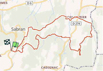

Length
14.3 km

Max alt
282 m

Uphill gradient
363 m
Km-Effort
19.1 km

Min alt
85 m

Downhill gradient
362 m
Boucle
Yes
Creation date :
2022-05-01 07:29:30.523
Updated on :
2022-05-01 12:37:08.729
3h27
Difficulty : Medium

FREE GPS app for hiking
 SityTrail
IGN / Geographical institutes
SityTrail Plus
The world is yours!
About
Trail Walking of 14.3 km to be discovered at Occitania, Gard, Sabran. This trail is proposed by poisson1103.
Description
avec Claudine et Françoise
Photos


Positioning
Country:
France
Region :
Occitania
Department/Province :
Gard
Municipality :
Sabran
Location:
Unknown
Start:(Dec)
Start:(UTM)
623466 ; 4888726 (31T) N.
Comments