


utgtrack-7603

starco
User
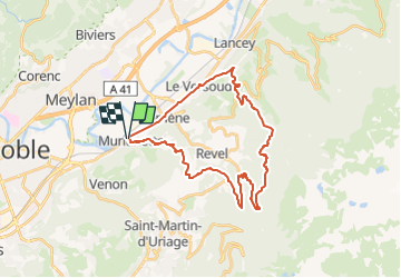

Length
30 km

Max alt
1193 m

Uphill gradient
1211 m
Km-Effort
46 km

Min alt
212 m

Downhill gradient
1214 m
Boucle
Yes
Creation date :
2022-05-01 12:38:37.0
Updated on :
2022-05-01 12:38:44.65

FREE GPS app for hiking
 SityTrail
IGN / Geographical institutes
SityTrail Plus
The world is yours!
About
Trail of 30 km to be discovered at Auvergne-Rhône-Alpes, Isère, Murianette. This trail is proposed by starco.
Positioning
Country:
France
Region :
Auvergne-Rhône-Alpes
Department/Province :
Isère
Municipality :
Murianette
Location:
Unknown
Start:(Dec)
Start:(UTM)
721295 ; 5008156 (31T) N.
Comments