


GELLES. TACROT

Papou63patrick
User
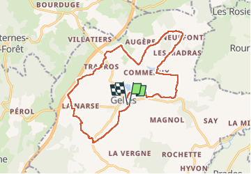

Length
18.1 km

Max alt
945 m

Uphill gradient
275 m
Km-Effort
22 km

Min alt
841 m

Downhill gradient
275 m
Boucle
Yes
Creation date :
2022-05-01 07:41:08.279
Updated on :
2022-05-01 12:54:20.395
3h56
Difficulty : Easy

FREE GPS app for hiking
 SityTrail
IGN / Geographical institutes
SityTrail Plus
The world is yours!
About
Trail Walking of 18.1 km to be discovered at Auvergne-Rhône-Alpes, Puy-de-Dôme, Gelles. This trail is proposed by Papou63patrick.
Positioning
Country:
France
Region :
Auvergne-Rhône-Alpes
Department/Province :
Puy-de-Dôme
Municipality :
Gelles
Location:
Unknown
Start:(Dec)
Start:(UTM)
481754 ; 5068269 (31T) N.
Comments